Winter Weather Returns to Lincoln This Weekend
(KFOR NEWS January 14, 2022) A fast-moving weather system brings rain to Lincoln on Friday, but by sunset, that changes over to snow.
The Weather Team at our partner, 10/11 NOW says the complicated nature of this weather-maker means we will see the threat for differing precipitation-types including rain…freezing rain…drizzle…freezing drizzle…sleet and accumulating snow…as well as much colder temperatures and winds that could gust to 40 mph at times. Friday morning we could see rain..freezing rain or sleet developing.
During the afternoon hours periods of rain will be transitioning to snow at some point…especially later into the afternoon or evening. As temperatures cool Friday night…most of the moisture is expected to be snow…with the greatest threat for accumulating snow over the eastern-third of the state as gusty north winds of 15-to-30 mph will gust to 40 mph. Much of western and central Nebraska will see little-or-no significant snow, but will deal with colder temperatures and gusty north winds.
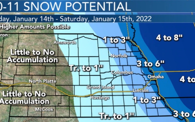
It will be another tough call on snowfall potential…with the usual suspects (storm track and timing)…but with the added “wild card” of “temperature” added in. If it’s warm enough we may see more rain or drizzle…if the cold air comes in sooner, we’ll see higher snow totals. Here’s a look at our snowfall forecast as of Thursday at 5pm.
It will be another tough call on snowfall potential…with the usual suspects (storm track and timing)…but with the added “wild card” of “temperature” added in. If it’s warm enough we may see more rain or drizzle…if the cold air comes in sooner, we’ll see higher snow totals. Here’s a look at our snowfall forecast as of Thursday at 5pm.
High temperatures on Friday will end up in the mid 30s-to-mid 40s.
Lows by Saturday morning will be much colder with readings in the single-digits and teens…and with those strong north winds many of us will see wind chills well below zero to start the day.
Highs on Saturday will “struggle” into the teens…20s…and 30s, with areas receiving the most snow certain to be the coldest. Winds should diminish by afternoon.
Highs on Sunday will rebound back into the 30s…40s…and lower 50s under variably cloudy skies.
READ MORE: Malcolm And Waverly Awarded $862,000 For Owner-Occupied Housing Rehabilitation Program
Blaze Events

Lincoln Calling
3 days ago
Clash at The Complex
7 days ago
Spring Game Tailgate!
1 week ago
In This Moment – Ice Nine Kills
1 week ago